Rainsford Island: The Quarantine Island

Lying between Long island and Peddocks Island, Rainsford Island is located in a relatively calm open area in the middle of Boston Harbor, just north of Quincy Bay. Once used as a quarantine station, this a centrally located but very small island in the middle of the harbor. It is said that the island derives its name from Edward Rainsford, who owned the island in 1632. The island has no remaining structures except the foundation of a quarantine hospital and seawall on its exposed Northeastern side. With no public dock or ferry service, Rainsford requires a private boat to access. Below is a view of Rainsford Island looking west on a rainy spring day, with Long Island’s water tower is visible in the distance:

boston harbor

An Eastward-looking view from the top of Rainsford Island’s North Drumlin.

boston harbor

 The most prominent part of Rainsford’s history is its role as a quarantine station and hospital: Ships arriving from international destinations were required to unload passengers who would sit at quarantine before entering the city. Here, quarantined patients would wait until they either recovered or died. Several nearby features are named for the quarantine station: These include the Quarantine Rocks, a dangerous line of rocks located South of the Island, and the Hospital Shoal, a shallow area north of Rainsford which is popular for fishing. The location of the quarantine rocks and the Hospital Shoal can be seen in the NOAA chart of Rainsford Island below:

boston harbor

Source: NOAA nautical chart. See disclaimer at NOAA.gov

Below are the quarantine rocks, Looking back towards the city of Boston, with the low lying section of Long Island in the foreground, Spectacle Island’s drumlin behind that, and finally the city skyline.

rainsford island

This stone cross sits near the top of Rainsford’s North drumlin. While it is not labeled, perhaps it is a memorial to someone who died while waiting at the quarantine station:

boston harbor

A beach covers the narrow spit between the two bluffs, which offer shelter. This is a popular place among kayakers and is also evidently a popular place for Graffiti:

beach rocks

Terns sit perched upon the remaining pilings of the old pier at Rainsford. Here is a photo from the Boston Public Library of how the pier once looked. The remains of this pier are a navigational hazard: While well marked on charts, the pilings are lie just below the water and are mostly not visible at high tide. See the chart above for location:

rainsford island

Aside from the island’s history as a quarantine station, it was used extensively as a reform school for boys in the early 20th century. The school was called the Suffolk School for boys and was closed in 1920s. Below is a photo of the school grounds which shown the contour of the island. A full photo stream is available at the Boston City Archives flickr page. The photo is taken from the southern bluff looking toward the north bluff, with the protected sandy cove in the center. Note that the wharf is visible on the far right of the photo: that wharf lies in ruins today but its remains are still visible (such as in the photo above).
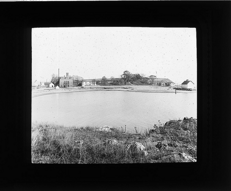
Boston Harbor Photo listed as a public domain work with the following citation: Children’s Institutions Department lantern slides, Collection #8500.002, City of Boston Archives, Boston

A present day view from the exact same spot:

Boston Harbor

A more obscure part of Rainsford’s history is that it used to be home to a well known lobsterman’s shack called Portuguese Joe’s, which is was on the south side of island near quarantine rocks. One night in June of 1938, the shack burst into flames in a conflagration that could be seen for miles. Police received so many calls about the blaze that reports of the incident made it into the papers in subsequent days.

The dunes of Rainsford’s Northwest side, with Long Island in the background. The area between Rainsford and Long Island is an ideal place for a small motorboat on most days. The area is protected from Southwest wind chop by Long Island’s high dunes, and is protected from open ocean’s swell by Georges and Lovells Island islands to the East.

rainsford island boston harbor

Another view of the city behind quarantine rocks on the south side:

quincy bay

The island’s smaller south bluff:

boston harbor

Rainsford Island is a popular with boaters, not just for fishing at hospital shoal but for anchoring and swimming as well. It probably would not be my first choice of islands to visit due to its small size and relatively central location. However, there are some interesting historical sites to explore and stories around them. There is a great overview of these posted at New England Folklore.

Rainsford Island from Hospital Shoal at dusk:

boston

Posted in Boston Harbor History, Uncategorized, Visiting Boston Harbor | Tagged , , , , , | Comments Off on Rainsford Island: The Quarantine Island

Navigating Nahant: Rocky shores and military ruins

lifesaving museum

Above: The Nahant Lifesaving Station, located near the entrance to the town.

Just a few miles north of Boston is the peninsula of Nahant, which is is known for its beaches, but is perhaps less well known for its military structures. Nahant is a unique geological feature: A rocky land mass connected to the mainland by a long, sandy neck. The outer shore, with its roadway currently under construction (June 2013) is a great beach that often gets some decent surf when there is an eastern swell. The rocky land mass at the end extends down so far from its head near the towns of Revere and Lynn, that one feels almost in Boston Harbor when standing there: In fact, Nahant is less than four miles from Graves Light, making it an easy day trip from Boston Harbor by boat.

Nahant is seems a bit of an insular place, perhaps as a result of its relatively difficult accessibility. For this reason, the place is likely better explored by boat or bike than by car: I don’t think I have seen a place that made it more clear that one would be towed if they parked at one of the town’s facilities without a resident parking sticker! So, being it early in the season, I risked it. I later followed up with a few photos from the boat.

Below is a view of the city of Boston from a hill in Nahant’s Lodge Park, named for former US Senator Henry Cabot Lodge. Clearly visible are the two fire control towers build by the military in the WWII era. Similar towers can be found all along the Greater Boston Coastline, from Halibut Point in Rockport down to Brant Rock in Marshfield.

boston harbor north shore

Nahant’s position made it a logical place for more military fortifications: As such, the government build several batteries around Fort Ruckman and the Lodge property on the southern shores of the peninsula. Battery John B. Murphy, seen below was built in WWII. From this location, any unfriendly intrusion into Boston Harbor could be stopped rather quickly with fire from the battery’s 16″ guns. Also because of its removed location relative to Boston, Nahant was integral to the system of submarine detection in WWII. This was a series of wires running from Nahant to the other far end of the outer Boston Harbor at The Glades in Scituate. A very detailed resource about it can be found here.

The ruins of these structures can be seen today at two separate locations: around Lodge Park and at Bailey’s Hill Park in Nahant. Below, the remains of the first casemate at Battery Murphy can be seen, along with the fire control towers and the city skyline in the background. The casemate is surrounded by dense growth:

nahant

The battery near its front entrance: overgrown, but still somewhat accessable:

nahant

The second casemate, which is even more secluded and covered with brush.

nahant

The second casemate, as seen from a few hundred yards offshore:

batery williams

The fire control towers, as seen from the water:

Views and perspectives of Nahant: Below, the view looking south from Lodge Park is rather unique in that one can see both Graves Light (near right) and Minot Light (far left) off Scituate. This open, elevated perch provides for some good perspective on the expanse of Massachusetts Bay. On the horizon, just to the left of Graves lighthouse, one can see the outline of the Lawson Tower, another good landmark.

graves light view

A view looking north from Henry Cabot Lodge park on a bleak spring day. Visible are various rock outcrops off Marblehead Neck, as well as Salem Sound and Gloucester.

nahant

A view of the park from the water. Note the absence of trees and the military structures on these rocky ledges. I have heard that these shores were the backdrop used in filming the Lighthouse scene in the movie Shutter Island.

park view

A prominent feature of the Nahant shoreline is Egg Rock, a steep and rocky island rising abruptly from the ocean northwest of the Nahant peninsula. This island may make a good diving location as I noticed several divers nearby. However, it seems difficult to beach on, and probably a bit too steep to attempt hiking:

nahant

An old boat near the entrance to Nahant. Its inscription should read, “welcome to Nahant, just don’t even think about parking here!”

nahant

Posted in Uncategorized | Tagged , , , , | Comments Off on Navigating Nahant: Rocky shores and military ruins

Picture of the week: Old Boat

This broken old boat caught my eye:

broken old boat

It was sitting near the Pemberton Point boat house in Hull. Surrounded with weeds and paint peeling off its hull, this boat had likely not seen any action on the water in quite some time. However, its skeleton that remains shows that this was a well built old boat.

boston harbor

hull bay

Posted in Boston Harbor Picture of the Week, Visiting Boston Harbor | Tagged , , , | Comments Off on Picture of the week: Old Boat

Happy 4th of July! USS Constitution in Boston Harbor

boston harbor

The USS Constitution was back out in Boston Harbor today for its annual July 4th turnaround and gun salute. Once again it was a nice day. Note the old American Flag flying off the stern.

A closer in, color shot courtesy of our pal, @jaybird508:

boston harbor

A faded version…kind of cool:

boston harbor

Posted in Boston Harbor History, Boston Harbor Navigation, Visiting Boston Harbor | Tagged , , , | Comments Off on Happy 4th of July! USS Constitution in Boston Harbor

Battleships and Destroyers: USS Wisconsin

Our buddy Captain Rob visited the Norfolk Shipyard in Virginia this week and took a tour of the USS Wisconsin, an Iowaclass battleship that is one of the biggest ever built. Here are some photos of the Wisconsin, in honor of the upcoming 4th of July holiday. Additionally, I have included information about a few more US Navy ships you may be able to see around the Boston Area.

The USS Wisconsin is an Iowa Class ship, one of five of the largest battleships built by the US. At 887 feet in length, these are the longest battleships ever built, although they are not the largest in terms of displacement: (That title would go to the Japanese Battleship Yamato, but this vessel was blown to pieces by the US Navy off Okinawa in 1945). Here are the big guns of the Wisconsin:

big guns

Some other destroyers, cruisers and aircraft carriers in the large Norfolk Ship Yard, which remains one of the largest and busiest Navy yards in the country:

destroyer battleship

USS Wisconsin at dock, as seen from the stern:

norfolk virginia

 The view from up on deck:

norfolk virginia

The silhouette of some big guns:

uss wisconsin

Navy ships you can see around Boston: there are several places to view these ships in the Boston area: These include Battleship Cove in Fall River, which is the largest collection of naval ships in the world, including the battleship Massachusetts, which while a major battleship, is still about 200 feet shorter than the Wisconsin! Smaller on the scale of navy vessels is the Destroyer and Cruiser. Two of these can be seen in the Boston area, including the USS Cassin Young in the Charlestown Navy Yard, and the USS Salem docked in the Fore River shipyard in Quincy.

Battleship USS Massachusetts (it looks big but Wisconsin is 200 feet longer!):

fall river

The Heavy Cruiser USS Salem at the Fore River Shipyard in Quincy:

Boston Harbor

The light destroyer USS Cassin Young in East Boston (usually at Charlestown):

boston harbor

Posted in Boston Harbor History, historical place of the week, Off course, Tour Boats, Uncategorized | Comments Off on Battleships and Destroyers: USS Wisconsin

Graves Light

boston harbor

This outer beacon in Boston Harbor sits far removed from any part of the mainland: Eleven miles from downtown Boston to be exact. Its grey and sublime silhouette combined with its perch above a treacherous rock outcrop makes for an intimidating appearance.

On a clear day, the view from the Graves is terrific. The North Shore and South Shore seem to melt together as one get a 180 degree view from the Northeastern outcrops of Rockport, back down to the Boston Skyline, and then out to the Scituate Glades, Minot light and even Marshfield to the South. On a very clear day, one might even see the Twin Lights of Thatcher Island in Rockport and Minot Light in Scituate from the same vantage point. While I am typically out at Graves at least once per week, I was recently taken aback by the tremendous view on a clear calm day, which I summed up as follows:

Venturing out past The Graves one calm summer day,
I found seas to be smooth, tranquil, and gray.

A great distance opens, across which to gaze,
as long rocky shores give way to horizon’s haze.

North, to the end of Cape Ann’s outcropped reach,
and South to Scituate’s glistening beach,

A vast and isolating stretch of sea
That lies behind the distant silhouette of a towering city.

Graves also looks particularly cool at sunset.

Graves from the #4 buoy at Martin’s Ledge:  

boston harbor

Graves Light up close: 

boston harbor


The Graves is largely approachable if one is careful to avoid the Roaring Bulls to its South and the Graves Ledge to its northwest. This light house sits at the entrance to the northern President Roads channel and is still a quite relevant beacon to those large ships (read drawing over 60+ and exiting the city) given that the “all clear” RW Buoy is still 5 miles WNW of here. Here is a shot of the distant city behind the rocks of Graves Ledge.

boston harbor

Posted in Boston Harbor Day Boat Trips, Boston Harbor Navigation, good views, Uncategorized, Visiting Boston Harbor | Tagged , , , | Comments Off on Graves Light

The Lookout Island: Lovells Island and Fort Standish

One of the old lookout towers on Lovells Island, looking West toward the City:

boston harbor

Lovells Island is positioned in a central, highly strategic location; where the Boston Harbor meets the Atlantic Ocean. Situated at the very outer harbor between the channels of President Roads to the North and Nantasket Roads to the South, Lovells is located in proximity to all of Boston’s major shipping traffic lanes, making it the perfect lookout over the outer Boston Harbor. This is likely the reason why the military built the massive, fourbattery Fort Standish on its shores in the 1890s.

Today, while the military fortifications have long fallen into ruins, this outward island still offers a tremendous lookout onto Massachusetts Bay for recreational visitors: its position is almost like a barrier island, evenly bridging a gap between Deer Island to the North and the Hull peninsula to the South. This is truly the barrier between Boston Harbor and the Atlantic Ocean: The distant outer islands of Brewster, Calf and Green that lie East of here are not really harbor islands, but are actually surrounded totally by the open Atlantic. As a result of its rocky topography and outer location, Lovells has particularly clear water on the long and flat beach on its eastern end.

History: The island has some notable history, particularly of some famous shipwrecks and the discovery of the bones of pirates who once camped out on the island. However, the major modern historical significance of the place is Fort Standish, which was used as one of Boston’s major military fortifications over the past century. The island is likely named for William Lovell, a local trader of the early 1600s, but it is unclear whether the many roads and streets around Boston bearing the name Lovell are related to this same individual. The island was originally granted to the city of Charlestown for farming, and was subsequently used as a quarantine station and an anchorage for arriving ships. The island previously had two large lighthouses which no longer remain. Today, the island remains covered with ruins, including this crumbling old brick structure on the north side of the island, visible against the dunes of Great Brewster Island in the distance.

boston habor

The structure seen above was used to store the oil to light the Lovells Island range lights, which were torn down in 1939 to expand Fort Standish. Virtually no remains of the lights are present today, with the exception of some wooden pilings. A US Coast Guard photo of how the lights once looked can be seen below. Note the oil shed was located in the middle:

boston harbor

Source: United States Coast Guard (USCG.mil)

Views from Lovells Island: This island provides some of the most expansive views of the rest of the Harbor. While it lacks the height of Spectacle or Great Brewster, this is made up for by its central location and long open stretches in most directions. The view to the East from atop the dunes of Lovells includes the Great Brewster Spit, The Brewster Islands, and Boston Light, with open ocean behind:

Boston Light View

Looking West from the main dock, one sees The Narrows, a frequently used shipping channel between Lovells and Gallops. Further back, the Northern head of Long Island is visible, with the city skyline in the distance:

boston harbor

Fort Standish:

This massive fort is little known, yet is surprisingly large structure with four batteries facing out toward the Atlantic Ocean. It rivals in size both of Boston’s better known military fortifications; Castle Island’s Fort Independence and Georges Island’s Fort Warren. Being infrequently visited as it is, the fort is quite overgrown and unmaintained, giving it a creepy feeling. The Fort was names after Miles Standish, and was used heavily in both World Wars after having been built in the 1890s. More detailed information about the fort can be viewed here.

lovells island

Below is Battery Burbeck, the southernmost of the four large batteries of the fort. From here, a large gun could fire at an enemy vessel approaching either harbor entrance.  A great photo of the way this battery looked when it was commissioned can be seen here, at the Boston Public Library’s photo collection.

lovells island

The area around the northern wall of the battery is particularly overgrown:

lovells island

Steps to the lookout tower at the top:

lovells island

Inside the Fort’s overgrown walls:

fort standish

lovells island

lovells island

A view of the Northern tip of Lovells, where there is commonly known to be a caved-in tunnel underneath the harbor which can still be explored (although this is not something I have attempted, nor would I recommend)! Green Island and Graves Light sit in the distance behind the collapsed seawall:

graves light view

The old roads on the island are cracked and overgrown:

boston harbor islands

A view to the Southwest, with Gallops Island sitting across the narrows. A long spit at Gallops is well marked with a large, green tower (visible at left):

boston harbor

A zoomed in city view from the island’s northwest side, with Nix’s Mate visible in the lower right corner, and Long Island Head visible on the lower left:

City of Boston view

A view across to the Brewster Island Spit at low tide. On this particular day, some brave windsurfers had taken to the spit via kayak and then launched.

great brewster spit

Lovell’s as seen from the top of Fort Warren on Georges Island:

Boston Harbor Islands

The center of the eastern side of the Island is a nice place to dock, although one must take caution of the Rams Head Flats, a long flat bed of rock outcrop only visible at low tide. The flats can be seen in the background of the photo below if you look carefully:

boston Harbor

A close-up of the crystal-clear water on Lovell’s East side, with the Brewster Islands visible in the background:

clear water

Accessing Lovells Island: The features of the island are relatively simple. Its is a flat island, with its dunes not rising more than 80 feet or so inland. On the Eastern End, the beach is long and flat, looking almost like a barrier island against the open Atlantic: Other than some cover from the Calf Island and Great Brewster Island, Lovell’s eastern shore is totally exposed.

To both the North and South, there are shallow spits extending East, probably formed over the ages by currents. The shallows at the northern end of the Island, known as the Ram’s Head Flats, are particularly expansive and can trip up even an experienced boater who mistakenly deviates outside the green buoys of the President Roads South Channel. The eastern side is particularly popular for anchoring and swimming. Two areas near Lovell’s make the top boating dangers of Boston Harbor list: Both the Ram’s Head Flats and the Great Brewster Spit.

On the western side of the island, the main dock can be found toward the southern end, as well as the ruins of an old pier further north. This area to the West of Lovells is also known as The Narrows, a channel still used today for medium or light shipping traffic heading south out of the Inner Harbor. A famous shipwreck, that of the French ship Magnifique, occurred here in 1782. The ship sunk and was never recovered, and while the exact location of the wreck is unknown and likely buried under tons of sand, a particular spot in this area shows some very jagged ocean floor on a sonar display…perhaps it is the remaining structure of the ship!  Around the corner from this area is an place of strong current which flows between Lovells and the Brewster Spit: Known as the Black Rock Channel (visible on chart below) this is a popular area for boaters to anchor and fish for flounder and fluke.

The main dock at Lovells Island up close:

boston harbor islands

A chart showing Lovells Island and the nearby area. Note the surrounding islands as well as the Rams Head Flats, Black Rock Channel and Great Brewster Spit:

boston harbor lovells island

Source: NOAA Nautical Chart. Not for official navigation. See disclaimer at NOAA.gov.
Posted in Boston Harbor Day Boat Trips, Boston Harbor History, Boston Harbor Navigation, good views, Uncategorized, Visiting Boston Harbor | Tagged , , , , | Comments Off on The Lookout Island: Lovells Island and Fort Standish

Portland Head Light: America’s most scenic lighthouse

Portland Head Light’s location and prominent features make it likely the most scenic lighthouse on all the Atlantic Coast:

maine

Visiting Portland Head Light: White surf pounds the outcrops of rock on a blue sky day. In the foreground is a sweeping horizon with clear deep blue sea below. Behind lies a green park surrounding a memorial to one of the largest WWII era batteries build to defend the city Portland, Maine.  This is the kind of stuff I live for!! For this reason, I had to include a post about Portland Head Light to this Boston Harbor−centric blog that this is. However it is easily justified as relevant: Perhaps by the fact that the territory of present−day Maine was part of the Massachusetts Bay Colony until it was incorporated as its own state in 1820. Overall, this is not only one of the most beautiful views on the planet, but is a great piece of New England’s nautical and military history.

The Light is located at a point at the end of  Fort Williams Park, an old military fortification now converted into a large park with great green lawns, and sweeping views of both Portland Harbor and the Atlantic Ocean.  Since colonial times, this little outcrop of rock served to guide ships safely into Portland; a port separating the open and treacherous Atlantic from the rich and highly desired land and timer resources of the inner lands. It was from these waters that explorers to the new world first sited the great white peaks of what is now New Hampshire’s Presidential Range; (At only 90 miles, Mount Washington is clearly visible from Casco Bay on a clear summer day). Scanning the horizon to the North, one sees land outcrops of rocky peninsulas that appear across the plain, interrupted by gaps of empty horizon: These are the bays and sounds that run deep up toward Maine country. This land was etched by glacial force and the carving torents of the forceful Androsscoggin and Kennebeck rivers as they carry the melted snows from The White Mountains down to the Atlantic.

Military history: Fort Williams was the outpost protecting Portland Harbor. The fort was positioned to guard the main entrance to the harbor: a narrow channel between Cape Elizabeth and Cushing Island. A view from the top of Fort William includes that of the fort itself, as well as Fort Georges in the distance, built on its own island. Portland was truly a heavily fortified harbor:

portland head

Across the entrance to Portland Harbor, toward Cushing Island:

portland head

Remains of an old battery, Battery Blair, near the Fort’s highest point:

portland head

Ruins of another battery positioned closer to the channel:

fort william

A chimney marking ruins of an old building close to the water. Most buildings don’t stand a chance against the raging Atlantic Ocean over time.

boston harbor

Views: On this particularly clear day, I had a great view of the area surrounding the Lighthouse. Here is a view of Ram’s Head Light, another lighthouse off the coast, which marks a dangerous rock outcrop. This lighthouse is visibly more weathered than the often painted and nicely maintained Portland Head Light.

portland harbor

From the shores of Fort Williams, one can see both lighthouses:

portland maine

To the South, Cape Elizabeth Lighthouse is visible. This area has a place called Two Lights State Park, not to be confused with the more impressive Portland Head Light.

maine

Further down in South Portland Harbor, Fort Georges is more visible:

portland harbor

South Portland Bug Light, at the entrance to the Harbor:

south portland

A final view of Portland Head Light, this time from the West:

maine lighthouse

Posted in Boston Harbor History, good views, Uncategorized | Tagged , , , | Comments Off on Portland Head Light: America’s most scenic lighthouse

World’s Largest Solar Powered Boat in Boston

The world’s largest solar powered boat, is docked in Boston Harbor this week at Fan Pier. The boat is called the Turanor, and is from Switzerland (The port of call is Basel, where the lovely Rhine River Flows). Some additional information about this solar powered vessel can be found at its home page, Planetsolar.org. Here she is up close:

boston harbor

And here she is from the water against the city skyline:

boston harbor

 This is one cool looking boat, but the question Boston area residents want to know the answer to: Is it WICKED fast?

Posted in Boston Harbor Navigation, Boston Harborfront Development, Uncategorized | Tagged , , , , | Comments Off on World’s Largest Solar Powered Boat in Boston

Historic place of the week: Quincy’s Furnace Brook

You may have driven down Quincy’s Furnace Brook Parkway, but what you may not know is that it is named for the country’s first iron blast furnace, which was built in 1644. You can see the remains of this furnace today, off Crescent Street in West Quincy, near Saint Mary’s Church. Here is what the remains of the original furnace looks like today:

furnace brook

In 1644, the furnace was built by John Winthrop Jr, a decedent of the Reverend John Winthrop, who was the founding governor of the Massachusetts Bay Colony.  John Jr. deduced that one could make crude iron from the ore found beneath the brooks, which he did at this location. The iron furnace was buried and forgotten for over a century, but was unearthed during an expansion of St. Mary’s Cemetery, which is located close by. Below is a closer view of the iron work’s foundation and the inscribed plate marking the sight:

winthrop furnace

The furnace brook was a place near which settlement took place as it provided access to good herring fishing. The nearby Adams house, home to two American Presidents, was built on the banks of this brook in 1720, as was the Dorothy Quincy House, which lies directly on the banks of the brook as well. Native Americans likely made use of the brook for fishing and hunting as well.  Originating near Saint Moritz Pond high up in the Blue Hills of West Quincy, the brook flows down through West Quincy, and curves around the South side of Forbes Hill. It then passes to the North of Quincy Center and curves sharply to the North near the Dorothy Quincy House, before it empties into Quincy Bay via Black’s Creek. Furnace brook flowing underneath the the railroad tracks at Newport Avenue. The stone structure is likely hundreds of years old:

newport ave

The  Black’s Creek area can be seen today when one passes over a small bridge at the East end of Quincy Shore Drive. Below is the outlet of Black’s Creek into Quincy Bay:

Blacks cove quincy

A marker memorializing Captain Wollaston, for whom the section of Quincy is named, located at the outflow of Black’s Creek:

wallaston

Related Posts Plugin for WordPress, Blogger...
Posted in Boston Harbor History, historical place of the week | Tagged , , , , | Comments Off on Historic place of the week: Quincy’s Furnace Brook